|
|
The 1948 War of Independence in a nutshell
By Maurice Ostroff Edited by Zipporah Porath
On November 29, 1947, the UN voted to partition western Palestine into separate Jewish and Arab States [1] . Although they were allocated a very much smaller area (including more than 75% desert), than had been promised in terms of the Balfour Declaration [2] , the Jewish leadership accepted partition. Regrettably, all of the Arab members states rejected it. Had the Arab states accepted partition then, there would be no Palestinian refugee problem today.
On May 15, 1948, one day after the State of Israel was declared, the Arab armies of Egypt, Syria, Jordan, Iraq, Saudi Arabia, Lebanon and the Arab Liberation Army commanded by Fawzi al-Kaukji invaded the new Jewish state. Arab League Secretary, General Azzam Pasha declared, “This will be a war of extermination and a momentous massacre which will be spoken of like the Mongolian massacres and the Crusades.”
The Grand Mufti of Jerusalem, Haj Amin Al Husseini, who had met with Hitler in 1941 and had been involved in recruiting support for Germany among Muslims during WW2 proclaimed, “I declare a holy war, my Moslem brothers! Murder the Jews! Murder them all!”
Against all reasonable expectations (even the CIA had estimated that the Jewish side would lose the war), the newborn state survived the onslaught although, at that time, its population comprised only 600,000 people in all, including women, the elderly and infants. Today, “new historians,” led by Benny Morris and Ilan Pappe, attempt to rationalize Israel’s survival in 1948 by claiming, without any foundation, that the Jews had superior forces and equipment.
But those, who participated in that war, know the absurdity of these revisionist claims, which run counter to the declarations of informed authorities, such as US Secretary of State George C. Marshall. He was reported to have warned Foreign Minister-to-be Moshe Sharett, before Sharett signed Israel’s Declaration of Independence, “Believe me, I am talking about things about which I know. You are sitting there in the coastal plains of Palestine, while the Arabs hold the mountain ridges. I know you have some arms and your Haganah, but the Arabs have regular armies. They are well trained and they have heavy arms. How can you hope to hold out?”
Periods of fighting were interrupted by temporary cease-fires and when the war officially ended in January 1949, Israel held the 5,500 square miles allotted to it by the UN partition plan, plus an additional 2,500 square miles. Transjordan held the eastern sector of Jerusalem and the West Bank, and Egypt held the Gaza Strip.
Armistice agreements were negotiated and eventually signed with Egypt, Lebanon, Jordan and Syria between January and July 1949, based on the lines at the end of the fighting.
Contrary to the impression many people have, Israel, in fact, is tiny. It is smaller than the. state of New Jersey in the USA, or the Kruger National Park in South Africa, with a vulnerable, narrow waist only 9 miles (15 km) wide.
Footnotes
- United Nations General Assembly Resolution 181
- In November 1917 the British Foreign office issued the Balfour Declaration which stated that the British Government viewed with favor the establishment in British mandated Palestine of a national home for the Jewish people, and would use best endeavors to facilitate the achievement of this object, it being clearly understood that nothing should be done which may prejudice the civil and religious rights of existing non-Jewish communities in Palestine, or the rights and political status enjoyed by Jews in any other country. The Mandated territory then included all of what is now Israel as well as present-day Jordan
|
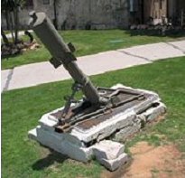
The name was said to be a tribute to the tiny, fledgling state of Israel fighting against the giant Arab armies Six Davidkas were manufactured in all. Two were given to each of the Palmach’s three brigades (Harel, Yiftach, and HaNegev). The most famous of them were those used by the Yiftach Brigade in the battle for Safed, where the monument in the picture stands today. |
The 1947 UN Partition Plan (Resolution 181)

|
The borders of the proposed Jewish State would have been indefensible. Overall, it was to comprise approximately 5,500 square miles, with a population of 538,000 Jews and 397,000 Arabs. The Arab State was to be 4,500 square miles with a population of 804,000 Arabs and 10,000 Jews. Jerusalem was to be administered as an international zone leaving more than 100,000 Jews in Jerusalem isolated and surrounded by proposed the Arab state. According to British statistics, more than 70 percent of the land in what would become Israel was not owned by Arabs. It belonged to the mandatory government. Map from Jewish Virtual Library.
http://www.jewishvirtuallibrary.org/jsource/myths2/Partition.html
|
INVADED BY SIX ARAB ARMIES

| On May 15, 1948, the day after Israel declared its independence, , the Arab League declared a “Holy War”, with the publicly declared intention of driving the Jews into the sea. Lebanon, Jordan, Syria, Egypt, Kaukji’s Liberation Army and Iraq invaded the newborn state. Among the first to fall were the isolated settlements of the Etzion Bloc, where the town of Efrat now stands. Map by Maurice Ostroff and Saville Kaufman. |

| By the time the armistice lines were drawn, the struggle for survival had cost Israel the lives of more than 6,000 of its total population of 600,000. The armistice left the country vulnerable with a waist only 9 miles wide (15 km.), with the Galilee dominated by the Syrian army on the Golan Heights and Egypt in control of the Gaza Strip. Jerusalem, which had been besieged and starved of food, water and arms, had been divided. Jordan, having expelled the Jews from the Old City, annexed East Jerusalem together with a large area on the West Bank of the River Jordan. Map by Maurice Ostroff and Saville Kaufman. |


 The Davidka – Typical of the primitive armaments available to the Jews in 1948, the Davidka (Little David) was a homemade Israeli mortar used by the Israel forces in the early days of the war. Its shells made extremely loud noises, but otherwise it was of little value.